Southern Africa is home to a flourishing climate full of unique species. The people of Southern Africa during this time used the geographic features and animals to their advantage, using it for housing and food. Southern Africa's Cape floral kingdom is one of the richest areas in the world for plant biodiversity.
Plateaus
|
The geography of Southern Africa can be described mainly by how high it is. The majority of the land is dominated by the Southern Plateau with elevations between 3,000 to 5,000 feet (900 – 1,500 meters) in elevation. Around the edges of the Plateau are a series of mountains and cliffs called the Great Escarpment. This includes the highlands in Zimbabwe and South Africa. From the highlands, the land drops to the coastal lowlands of South Africa and Mozambique. Southern Africa is bordered by two of the world’s oceans, the Atlantic on the west and the Indian on the south and east (Great Escarpment...).
|
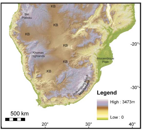
By Oggmus (Own work) [CC BY-SA 3.0 via Wikimedia Commons}
|
Wildlife
By Bernard Gagnon (Own work) CC BY-SA 3.0 via Wikimedia Commons
|
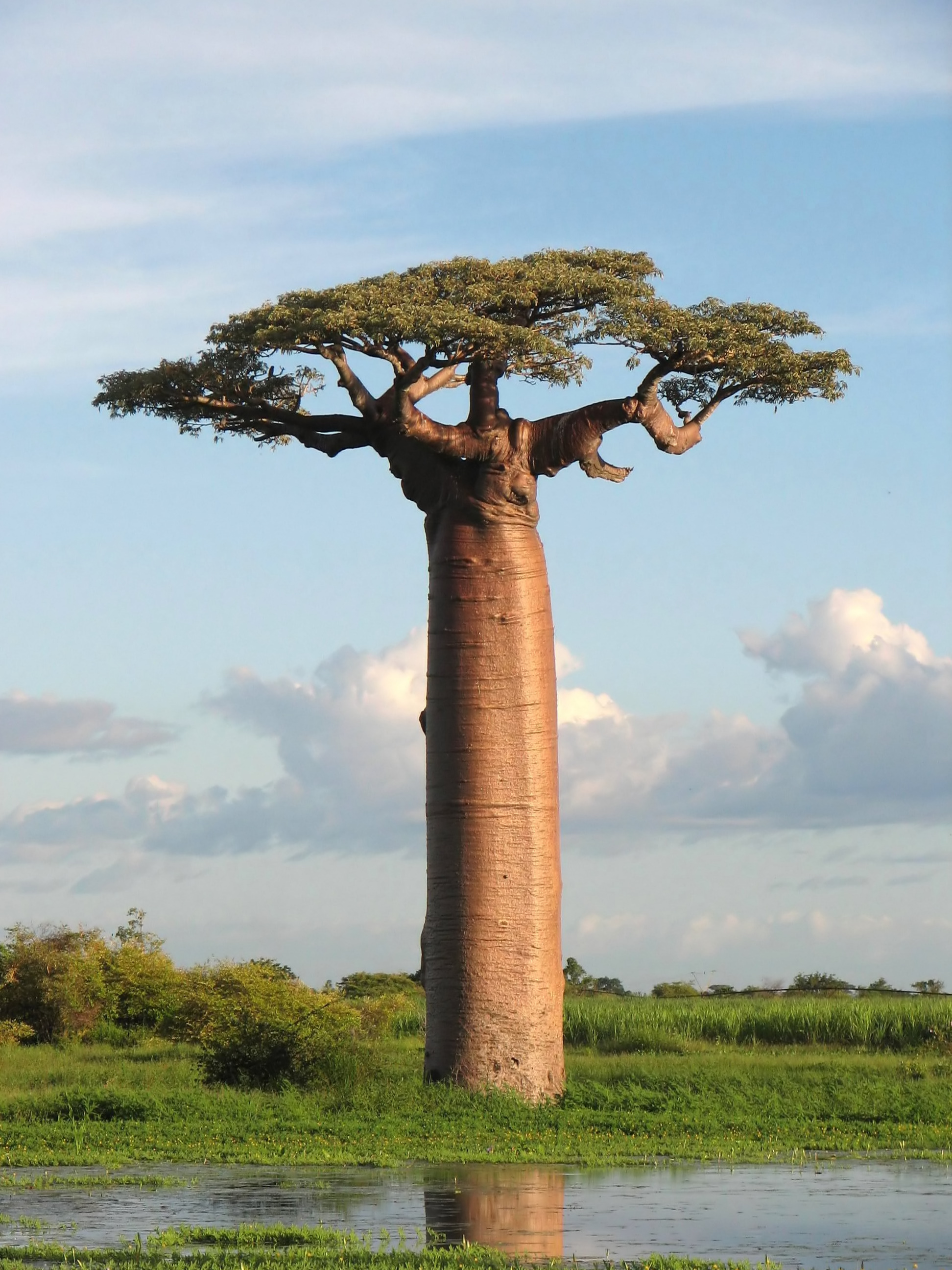
Southern Africa receives too little rain to support thick forests. Much of the land is savanna, with some fynbo heathland and desert. The western cape region of South Africa has more than 8500 species of fynbos, some species are found only there. The most common plants found here are the coconut palm, Acacia and Mopane trees. Mopane trees are very tolerant of poor soil conditions and therefore have a wide distribution throughout southern Africa. Africa is also home to the bizarre Baobab tree. Southern Africa also boasts more than 300 different kinds of mammals and more than 400 species of reptile. Many of the reptile species are only found in this region. Many large animals still can be found in the countryside, although National Parks are thought to be their best hope for long term survival (Moore).
|
Rivers
|
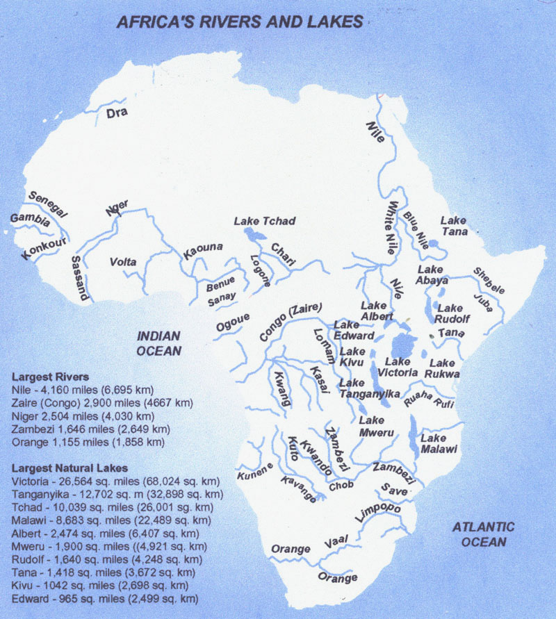
Southern Africa is home to a number of river systems. The longest of these rivers are the Zambezi and the Limpopo. The Zambezi plunges over the Victoria Falls and forms the borders of Zambia and Zimbabwe before flowing into Mozambique and the Indian Ocean. The Limpopo flows from South Africa through Mozambique and into the Indian Ocean. One river, the Okavango never reaches the ocean at all. It flows inland into Botswana’s Kalahari Desert where it forms the world’s largest inland delta, or river mouth. The Orange River is the only river in Southern Africa to flow into the Atlantic Ocean. Along the way, the Zambezi River flows over the mighty Victoria Falls on the border between Zambia and Zimbabwe. Victoria Falls is the largest waterfall in the world based on selected criteria and is a major tourist attraction for the region (Greene).
|
Used under CC BY-NC-SA 2.0
|
Sources
Great Escarpment (1998, July 20). In Encyclopædia Britannica. Retrieved April 5, 2017, from https://www.britannica.com/place/Great-Escarpment-mountains-Africa
Greene, K. (2001, May 1). In Southern Africa and the Total Solar Eclipse Expedition. Retrieved from http://www.questconnect.org/africa_sa_home.htm
[Creative Commons Attribution-NonCommercial-ShareAlike 4.0 International License], . (n.d.). Southern Africa. In World Regional Geography: People, Places and Globalization. Retrieved from http://open.lib.umn.edu/worldgeography/chapter/7-6-southern-africa/
Moore, A., Blenkinsop, T., & Cotterill, F. (2009, May 18). Southern African topography and erosion history: plumes or plate tectonics?. In via mantleplumes.org. Retrieved from http://www.mantleplumes.org/WebDocuments/Moore2009.pdf
